Market Definition
The market involves the collection, processing, and distribution of high-resolution Earth imagery of the Earth's surface captured by satellites for various commercial applications.
This market encompasses services and solutions that utilize satellite imagery for urban planning, agriculture, environmental monitoring, disaster response, defense, and infrastructure management.
Commercial Satellite Imaging Market Overview
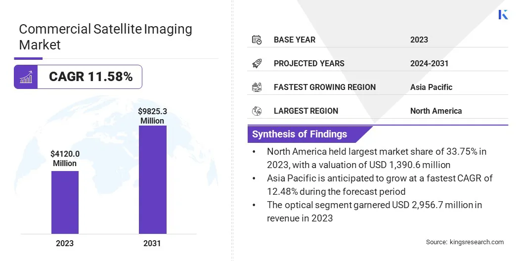
The global commercial satellite imaging market size was valued at USD 4,120.0 million in 2023 and is projected to grow from USD 4,561.9 million in 2024 to USD 9,825.3 million by 2031, exhibiting a CAGR of 11.58% during the forecast period.
This robust growth is driven by the increasing demand for precise geospatial data across diverse industries such as agriculture, defense, environmental monitoring, and urban development.
The expanding use of satellite imagery for critical applications such as infrastructure planning, disaster response, and resource management is further fueling market expansion. Technological advancements, including higher image resolution, enhanced data analytics, and the integration of artificial intelligence (AI) for improved image interpretation, are supporting this growth.
Major companies operating in the commercial satellite imaging industry are Airbus, Maxar Technologies, Planet Labs PBC, Capella Space Corp., Satellogic, BlackSky Technology Inc., ICEYE, Ursa Space Systems Inc., Synspective Inc., Earth-i Ltd, SI Imaging Services Co., Ltd., Northrop Grumman, Kongsberg Satellite Services, Twenty First Century Aerospace Technology (Asia) Pte. Ltd., and Geoimage.
Additionally, the growing adoption of satellite data in sectors such as energy, real estate, and forestry is enhancing operational efficiency and decision-making processes. The rising availability of cost-effective satellite services, coupled with government investments in space programs, is contributing to market expansion.
- In September 2024, Satellogic Inc. was awarded a spot among eight recipients for NASA’s Commercial SmallSat Data Acquisition Program (CSDA) On-Ramp1 contract, valued at up to USD 476 million. Under this contract, the company will provide high-resolution multispectral imagery to support NASA’s Earth observation efforts, including climate research, environmental monitoring, and scientific applications.
Key Highlights
- The commercial satellite imaging industry size was valued at USD 4,120.0 million in 2023.
- The market is projected to grow at a CAGR of 11.58% from 2024 to 2031.
- North America held a share of 33.75% in 2023, valued at USD 1,390.6 million.
- The optical segment garnered USD 2,956.7 million in revenue in 2023.
- The geospatial data acquisition & mapping segment is expected to reach USD 2,413.1 million by 2031.
- The government segment is projected to generate a revenue of USD 2,200.9 million by 2031.
- Asia Pacific is anticipated to grow at a CAGR of 12.48% over the forecast period.
Market Driver
"Rising Demand for High-Resolution Data and Strategic Intelligence"
The commercial satellite imaging market is expanding due to the increasing demand for high-resolution Earth observation data and the growing adoption of satellite imagery across key sectors.
Industries such as agriculture, environmental monitoring, and urban planning are heavily investing in high-resolution satellite data to improve operational efficiency and decision-making. In agriculture, satellite imagery helps monitor crop health, detect soil variations, and manage irrigation systems, optimizing yields and minimizing resource waste.
Environmental organizations use satellite data to track deforestation, monitor water bodies, and assess climate change impacts. Urban planners rely on it for land mapping, infrastructure development, and traffic flow analysis.
- In March 2025, Pixxel announced that its three Firefly satellites successfully captured and downlinked the world’s highest-resolution hyperspectral images. With a 5-meter resolution across 150+ spectral bands and a 40 km swath width, the images covered ecologically and economically significant regions including the River Ganga in India, Saloum River Delta in Senegal, and the Sundarbans in India, providing critical insights for agriculture, climate monitoring, mining, and disaster response.
Additionally, satellite imagery is gaining prominence in defense, intelligence, and disaster management for enhanced surveillance and strategic decision-making.
Defense agencies use high-resolution data for border monitoring, detecting unauthorized activities, and analyzing potential threats. In disaster management, satellite imagery enables rapid assessment of affected regions, helping authorities allocate resources efficiently and plan recovery strategies.
Market Challenge
"High Cost of Deployment"
A major challenge hampering the growth of the commercial satellite imaging market is the significant costs involved in satellite deployment, maintenance, and data acquisition. Developing and manufacturing advanced imaging satellites requires substantial investment in precision engineering, materials, and technology.
Launch expenses, including payload integration and rocket services, contribute significantly to capital requirements. Moreover, ongoing maintenance, satellite calibration, and data accuracy demand continuous financial resources.
Managing and processing the massive volumes of imagery data collected by satellites adds to the economic burden, particularly for smaller enterprises or organizations with limited budgets.
Cloud-based platforms and data-as-a-service (DaaS) models offer cost-effective solutions to this challenge. They provide access to satellite imagery without the need for significant investment in data infrastructure.
By utilizing cloud services, businesses can efficiently store, process, and analyze satellite data, enhancing accessibility and reducing financial barriers across industries.
Market Trend
Advancements in AI and Small Satellite Constellations
The commercial satellite imaging market is experiencing significant advancements with the integration of AI and machine learning and the expansion of small satellite constellations. AI and machine learning technologies are revolutionizing satellite image analysis by automating data interpretation processes.
These tools enable rapid identification of patterns, detection of anomalies, and predictive insights. This enhances applications in agriculture, infrastructure monitoring, and environmental management, allowing for more efficient detection of crop health variations, predict deforestation risks, and infrastructure damages compared to traditional methods.
- In March 2025, Planet Labs PBC partnered with Anthropic to utilize Claude's advanced AI capabilities into geospatial satellite imagery analysis. This collaboration aims to combine Claude’s sophisticated reasoning and pattern recognition with Planet’s extensive Earth observation data for real-time global anomaly detection . The partnership is expected to improve insights in areas such as environmental monitoring, disaster response, and agricultural optimization, benefiting both government and commercial users.
Furthermore, the expansion of small satellite constellations is improving global coverage and revisit rates. These compact satellites, deployed in large numbers, provide more frequent data collection by orbiting the Earth at lower altitudes.
This increased revisit capability is crucial for monitoring rapidly changing conditions, such as weather patterns, disaster-stricken areas, and geopolitical activities. By ensuring faster data updates, small satellite constellations enable real-time decision-making for industries, including defense, maritime surveillance, and resource management.
Commercial Satellite Imaging Market Report Snapshot
|
Segmentation
|
Details
|
|
By Technology
|
Optical, Radar
|
|
By Application
|
Geospatial Data Acquisition & Mapping, Urban Planning & Development, Disaster Management, Energy & Natural Resource Management, Surveillance & Security, Defense & Intelligence, Others
|
|
By End-User
|
Government, Military & Defense, Forestry & Agriculture, Energy, Civil Engineering & Archaeology, Transportation & Logistics, Others
|
|
By Region
|
North America: U.S., Canada, Mexico
|
|
Europe: France, UK, Spain, Germany, Italy, Russia, Rest of Europe
|
|
Asia-Pacific: China, Japan, India, Australia, ASEAN, South Korea, Rest of Asia-Pacific
|
|
Middle East & Africa: Turkey, UAE, Saudi Arabia, South Africa, Rest of Middle East & Africa
|
|
South America: Brazil, Argentina, Rest of South America
|
Market Segmentation
- By Technology (Optical and Radar): The optical segment earned USD 2,956.7 million in 2023 due to its ability to capture high-resolution imagery for applications in urban planning, agriculture, and environmental monitoring.
- By Application (Geospatial Data Acquisition & Mapping, Urban Planning & Development, Disaster Management, Energy & Natural Resource Management, Surveillance & Security, Defense & Intelligence, and Others): The geospatial data acquisition & mapping segment held a share of 24.47% in 2023, fueled by increasing demand for accurate mapping solutions in infrastructure development and land management.
- By End-User (Government, Military & Defense, Forestry & Agriculture, Energy, Civil Engineering & Archaeology, Transportation & Logistics, and Others): The government segment is projected to reach USD 2,200.9 million by 2031, propelled by rising investments in satellite imaging for national security, environmental monitoring, and disaster response initiatives.
Commercial Satellite Imaging Market Regional Analysis
Based on region, the market has been classified into North America, Europe, Asia Pacific, Middle East & Africa, and Latin America.
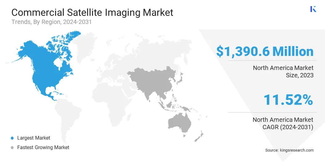
North America commercial satellite imaging market accounted for a substantial share of 33.75% in 2023, valued at USD 1,390.6 million. This dominance is attributed to the region's advanced space infrastructure, substantial government funding, and growing reliance on geospatial data across multiple sectors.
The United States, in particular, leads the regional market with strong investments in defense and intelligence applications, where satellite imagery is crucial for surveillance, border security, and disaster response. The integration of satellite data in sectors such as agriculture, forestry, and energy has expanded growth opportunities.
Increasing adoption of high-resolution imagery for environmental monitoring, including wildfire tracking and climate change assessment, has further contributed to regional market growth.
Moreover, North America's emphasis on technological innovation, such as integrating artificial intelligence (AI) and machine learning in satellite image processing, has enhanced data accuracy and decision-making. Expanding partnerships between federal agencies and commercial satellite service providers further bolsters domestic market expansion.
Asia Pacific commercial satellite imaging industry is expected to register the fastest CAGR of 12.48% over the forecast period. This growth is propelled by increasing investments in space programs, rising demand for geospatial data in agriculture, and rapid urbanization across major economies.
Countries such as China and India are heavily investing in satellite launches to support infrastructure development, resource mapping, and environmental monitoring. In China, advancements in remote sensing technology are enhancing applications in land use planning, disaster risk management, and precision agriculture.
India’s growing focus on smart city projects, along with the adoption of satellite imagery for crop monitoring, irrigation planning, and flood forecasting, is boosting demand for commercial satellite imaging solutions.
Additionally, Southeast Asian nations are increasingly adopting satellite data for marine surveillance, forestry management, and natural disaster assessment. The region’s rising focus on enhancing connectivity through satellite communication services is also contributing to regional market expansion.
- In February 2024, Geespace, a satellite technology and commercial services firm backed by Zhejiang Geely Holding Group, launched 11 satellites from China’s Xichang Satellite Launch Center. This achievement advances the “Geely Future Mobility Constellation” and enhances environmental monitoring and industrial applications through AI-powered remote sensing and high-resolution imaging.
Regulatory Frameworks
- In the United States, commercial satellite imaging is regulated by the National Oceanic and Atmospheric Administration (NOAA) under the Commercial Remote Sensing Regulatory Affairs (CRSRA) program. This framework enforces the Land Remote Sensing Policy Act of 1992, which requires commercial satellite operators to obtain licenses and adhere to national security, foreign policy, and international obligations. Additionally, the Department of Commerce ensures compliance with imaging restrictions, including limitations on high-resolution data for sensitive areas.
- In Europe, commercial satellite imaging is governed by the European Space Agency (ESA) and national-level agencies such as the Centre national d'études spatiales (CNES) in France and the UK Space Agency. The EU Space Programme outlines data security, environmental protection, and commercial satellite imaging standards.
- In China, commercial satellite imaging is regulated by the China National Space Administration (CNSA). The Regulations on the Management of Remote Sensing Satellite Ground Stations establishes licensing, data distribution controls, and security protocols to align satellite data with national security interests.
- In Japan, the Act on Space Activities, enforced by the Japan Aerospace Exploration Agency (JAXA) and the Cabinet Office, governs commercial satellite imaging. It mandates licensing for commercial imaging operators, data security standards, and compliance with international space treaties.
- In India, the Indian Space Research Organisation (ISRO) and the New Space India Limited (NSIL) oversee commercial satellite imaging under the Remote Sensing Data Policy (RSDP) 2011. The policy regulates data acquisition, distribution, and access control, balancing national security concerns with the growth of commercial satellite imaging services.
Competitive Landscape
The commercial satellite imaging industry is characterized by continuous technological advancements, increasing adoption of high-resolution imaging systems, and expanding application areas across industries.
Market participants are actively investing in enhancing image clarity, data processing capabilities, and real-time analytics to meet the growing demand for precise geospatial information.
Companies are focusing on developing advanced sensors, multispectral and hyperspectral imaging technologies, and AI-driven data interpretation tools to improve accuracy and expand the utility of satellite data.
Strategic collaborations among satellite operators, data analytics firms, and government agencies are fostering innovation and improving access to actionable insights. Cloud computing platforms enhance scalability, enabling faster delivery of satellite imaging data by streamlining storage, processing, and distribution.
Market participants are offering customized solutions for industries such as agriculture, defense, energy, and environmental monitoring to address specific operational needs.
The growing demand for on-demand satellite data services and improved tasking capabilities is shaping the competitive landscape, providing organizations with timely, relevant information for critical decision-making.
- In December 2024, Dhruva Space announced the launch of AstraView, a new commercial satellite imagery service offering high-resolution, real-time Earth observation data. This offering is enabled through strategic partnerships with industry leaders such as Array Labs, Axelspace, Capella Space, Geosat, Maxar, Planet, Satellogic, SI Imaging Services, Unseenlabs, and Wyvern. AstraView delivers Electro-Optical, Synthetic-Aperture Radar (SAR), Radio Frequency, and Hyper-Spectral imagery for the Academia, Defence, and Enterprise sectors.
List of Key Companies in Commercial Satellite Imaging Market:
- Airbus
- Maxar Technologies
- Planet Labs PBC
- Capella Space Corp.
- Satellogic
- BlackSky Technology Inc.
- ICEYE
- Ursa Space Systems Inc.
- Synspective Inc.
- Earth-i Ltd
- SI Imaging Services Co., Ltd.
- Northrop Grumman
- Kongsberg Satellite Services
- Twenty First Century Aerospace Technology (Asia) Pte. Ltd.
- Geoimage
Recent Developments (Collaboration/New Satellite Launch)
- In March 2025, ICEYE launched four new satellites, including its advanced Generation 4 (Gen4) satellite, enhancing its SAR constellation. The Gen4 satellite features a larger SAR antenna, doubled radiated SAR power, and an expanded imaging area with a 150 km to 400 km swath width. It also offers 30% greater information density, improved orbit control, and netter imaging of congested areas in a single pass.
- In January 2025, constellr launched its first thermal infrared monitoring satellite, SkyBee-1, aboard SpaceX’s Transporter-12 rideshare mission from Vandenberg Space Force Base in California. SkyBee-1 captures high-resolution thermal images with a 30m spatial resolution, sharpened to 10m, and temperature accuracy of 1-2 Kelvin. It is equipped with an eleven-band visible-near infrared instrument and a four-band thermal infrared (TIR) camera, providing continuous land surface temperature data to industries such as agriculture, infrastructure, and urban development.
- In June 2024, NEC Corporation and Ursa Space Systems Inc. announced a collaboration to enhance satellite image data analysis services. This partnership intergrates NEC’s Synthetic Aperture Radar (SAR) monitoring service with Ursa Space’s global image analysis platform, expanding NEC’s SAR-based capabilities within Ursa Space’s global offering.
- In May 2024, Raytheon, an RTX business, launched two next-generation imaging instruments as part of Maxar's WorldView Legion satellites. These instruments provide 30cm high-resolution satellite imagery for applications such as national security, commercial mapping, maritime monitoring, and disaster response. The WorldView Legion constellation, once complete with six satellites, will offer revisit rates of up to 15 times per day over densely populated regions, improving real-time observation capabilities.


